Upper Turkey Creek Project

2026
Upper Turkey Creek Flood Risk Management Project
Project Presentation
Monday, June 8, 2026 at 7 p.m. – City Council Meeting
Merriam Community Center, 6040 Slater St.
Presentation(PDF, 6MB)
Project Overview(PDF, 746KB)
Project Map(PDF, 4MB)
Frequently Asked Questions(PDF, 182KB)
At this meeting, the U.S. Army Corps of Engineers (USACE) presented their design plans for the project. The presentation provided an overview of their proposed improvements and how they are intended to reduce flooding along Turkey Creek.
Following the presentation, representatives from USACE and the project team were available to speak one-on-one and answer questions, including those related to specific properties.
It’s important to understand that no decisions have been made about how to reduce the risk of flooding in Merriam. USACE has studied the flood basin and prepared 50–65% design plans for improvements. The meeting was an opportunity to better understand what is being considered and how it may impact your property. A recording of the meeting can be viewed on YouTube.
Project Summary
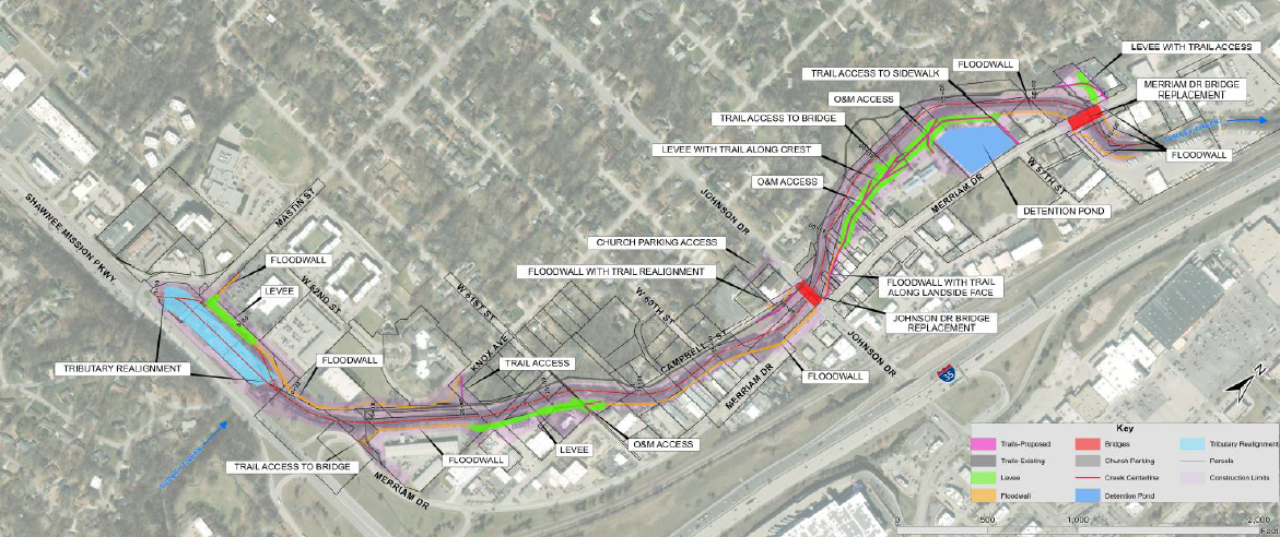
This project is a collaborative effort between the U.S. Army Corps of Engineers (USACE)and the City of Merriam to provide a long-term solution to flooding in Downtown Merriam. The project addresses historical and recurring flooding along a 1.5-mile stretch of Upper Turkey Creek. The project is currently at the 50% design milestone and encompasses the construction of levees, floodwalls, and the replacement of critical infrastructure.
Background and Purpose
The Upper Turkey Creek watershed has a well-documented history of severe flooding, with catastrophic events recorded in 1977, 1993, and the "flood of record" in 1998, which resulted in millions of dollars in damages to the local community. The downtown Merriam area is heavily developed, and current infrastructure cannot contain these floodwaters.
The primary mission of this project is to provide a comprehensive, permanent solution that protects the community against a 100-year flood event (1% Annual Exceedance Probability). Exhaustive studies have demonstrated that smaller-scale interventions are ineffective for this watershed. By executing this large-scale project, USACE aims to not only protect life and property but also establish a secure foundation for the City of Merriam’s long-term economic revitalization and Downtown Master Plan.
Key Plan Highlights and Engineering Features
To achieve the required level of protection, USACE has engineered a multi-faceted flood risk management system. The structural components are designed to withstand extreme forces, including flood loading, debris impact, and wind loads.
|
Feature Category
|
Design Specifications
|
Operational Purpose
|
|
Earthen Levees
|
Constructed up to a maximum height of approximately 10 feet.
|
To provide a resilient, naturalized barrier against rising water levels along the creek banks.
|
|
Concrete Floodwalls
|
Engineered concrete structures ranging from 6 to 12 feet in height.
|
Deployed in high-density areas where space constraints prohibit the wider footprint of earthen levees.
|
|
Bridge Replacements
|
Complete demolition and replacement of both the Johnson Drive and Merriam Drive bridges.
|
Existing bridges obstruct water flow and do not meet flood-management requirements. New structures are elevated and redesigned for maximum clearance.
|
|
Detention Basin
|
Construction of an 11.0-acre-foot grassed detention basin.
|
To collect, hold, and slowly release stormwater runoff, preventing the system from being overwhelmed during peak precipitation.
|
|
Interior Drainage
|
Installation and upgrading of numerous pipes, culverts, and drainage structures.
|
To ensure that water on the protected side of the levees and floodwalls is efficiently routed back into the creek or basin.
|
2026 Documents
Project Overview(PDF, 746KB)
Project Map(PDF, 4MB)
Real Estate Maps(PDF, 3MB)
Frequently Asked Questions(PDF, 182KB)
Upper Turkey Creek Flood Risk Management Project 50% Design Report(PDF, 475MB)
Upper Turkey Creek 50% Design Plan Set(PDF, 108MB)
Upper Turkey Creek Bridge Plans(PDF, 7MB)
2025
November 7, 2025
US Corps of Engineers Public Notice for the Upper Turkey Creek Programmatic Agreement Development
2024
March 2024
The U.S. Army Corps of Engineers on March 5 shared their progress of the Upper Turkey Creek Project with staff leaders from the City, Johnson County, and the Merriam Drainage District.
The U.S. Army Corps of Engineers presented several high-level solutions to address the threat of flooding along Turkey Creek. These solutions have varying levels of impact on this area, ranging from 8- to 13-foot flood walls, levees, and/or removing properties in and around downtown Merriam.
At this point, there’s been no determination of any single best option or the cost of each solution. The Army Corps will continue to dive into this information to learn more about the proposals and costs.
The Merriam City Council and Merriam Drainage District are committed to identifying the best option that protects properties near the creek from flooding, eliminates the need for local businesses to pay for flood insurance, and frees up property owners to reinvest in properties currently located in Historic Downtown.
Once more information is available and there are decisions to be made, we plan to hold a public meeting to share these potential solutions with the public and local business owners.
Please continue to visit this website to stay informed of any new updates. The Merriam City Council meets on the second and fourth Monday of each month at 7 p.m. in City Hall. The Merriam Drainage District meets at 7 p.m. at Higdon & Hale (6310 Lamar Ave #110, Overland Park) on the first Monday of each month.
2022
June 2022
The first steps are underway in reducing flood risk in downtown Merriam!
In June 2022, City Councilmembers approve a design agreement with the U.S. Army Corps of Engineers. The agreement was signed by Mayor Bob Pape and Col. Travis Rayfield to start the design phase of the Upper Turkey Creek Flood Risk Reduction Project, including preconstruction and engineering design.
Over the next three to four years, the Corps will determine how to best construct flood walls and levees along two miles of Turkey Creek, from Shawnee Mission Parkway to Merriam Drive.
We'll work closely with our partners at Johnson County and the Corps on the next steps and keep you informed of project happenings.
How We Got Here
2022 Documents
April 2022 - Kickoff Presentation(PDF, 13MB)
June 2022 - UTC Design Agreement(PDF, 626KB)
2015
2015 Upper Turkey Creek Study
Civil Works Review Board Presentation(PDF, 3MB)
Upper Turkey Creek Chiefs Report(PDF, 311KB)
Upper Turkey Creek Study(PDF, 10MB)
2015 Upper Turkey Creek drone video.
Frequently Asked Questions
How long will the design process take?
It can take up to two years to design the Upper Turkey Creek project.
When will construction start?
We expect a possible 2026-2027 construction start date.
Click here to view form.